Frequently Asked Questions
Communities Involved in Floodplain Map Changes
Information For
Floodplain Specialists
Info for Emergency Managers, Floodplain Administrators, and other Floodplain Specialists

Select a topic for more information
Or continue scrolling
Risk MAP Process Details
Risk MAP produces two categories of products.
Regulatory products are those that are used as the basis for official actions required by the National Flood Insurance Program. They include these three items:
Non-regulatory products supplement the flood hazard information produced by the regulatory FIRM, Flood Insurance Study, and database products. Both the general public and government officials are encouraged to use these free resources to help make better informed decisions about preparing for and mitigating flood loss.
They include:
- Water Surface Elevation (WSE) Grids
- Depth Grids
- Percent Annual Chance Grid
- Percent 30 Year chance grid
- Changes Since Last FIRM
- Areas of Mitigation Interest
There may be additional flood studies that do not meet the definition of a regulatory product and may not be identified on a regulatory FIRM. This can include but is not limited to: Erosion Hazard Zone studies, Active Alluvial Fan designations, and flood after fire analysis. Training in the use of products, flood risk communications may also be requested by project communities.
***************
For more detail click on the following links:
Here in Utah, Risk MAP is a collaborative process between FEMA, the State Division of Emergency Management (DEM) and local community representatives.
FEMA is responsible for the overall administration of the Risk MAP program. It provides funds to Cooperating Technical Partners (CTP), develops standards and guidance for its implementation, and reviews all Risk MAP products. Representatives from FEMA Region 8 often provide direct support to Utah projects.
Utah’s Division of Emergency Management is currently Utah’s sole Cooperating Technical Partner. By working through a local CTP like DEM, FEMA’s Risk MAP program achieves 1) better overall flood risk identification and community protection, 2) improved communications and community outreach, and 3) improved awareness of critical mapping needs. Utah DEM contracts private engineering firms to collect data, run hydraulic and hydrologic models, and create regulatory and non-regulatory products.
Community officials help focus and prioritize the need for new projects, review the development of products for ongoing projects, and communicate project results to their colleagues and communities. We create Risk MAP products with floodplain managers, emergency managers, and community planners in mind as the primary users.
A Risk MAP project can take up to 5-7 years to complete. Factors affecting project length include:
- The scale of study
- The number of stream miles
- The type of study (alluvial fan, riverine, coastal, or watershed modeling)
- The existence of pre-existing data provided by the community
- The length of time needed for the review by FEMA and/or community partners
- Whether or not there are community appeals
Since the purpose of Risk MAP products is to aid communities in protecting lives and property, we need our flood risk products to be as technically accurate as possible. They should also reflect community knowledge and experience. To accomplish this there are a number of review stages throughout each project.
Community review stages:
1. Once the Risk MAP team and community have discussed mapping needs, the Risk MAP team develops a map of proposed enhanced study streams for the community to review.
2. During the Data and Product Development Phase, the Risk MAP team organizes meetings to explain and demonstrate the study process and results to date. These meetings may include a hydrology meeting, a flood risk review meeting, floodplain review, and a resilience meeting. Other meetings may occur as needed. Due to the technical nature of the Risk MAP process, communities find it helpful to have their city or town engineer participate in meetings and reviews.
3. After the hydraulic and hydrologic modeling is completed, draft floodplains are delineated and mapped. The Risk MAP team holds a Flood Risk Review Meeting to give community officials the chance to review and provide early feedback on this draft information before the Preliminary MAPS (FIRMs) and FIS report and other flood risk products are developed.
4. When the Preliminary Maps (FIRMs) and FIS report are released, digital and paper copies are sent to affected communities for review and comment. They are also posted on FEMA’s Flood Map Service Center. Following Preliminary FIRM and FIS release, a Consultation Coordination Officer (CCO) meeting is held with community officials to discuss the process for the formal review and adoption of the floodplain study.
5. There is a 90-day appeal period for communities with new or updated flood hazards. This begins after a public notification process is completed. During this period, communities or the public (through their community officials) can submit data to revise the FIRM if they believe it is scientifically or technically incorrect.
Utah Risk MAP technical review
6. Each engineering firm hired by Utah Risk MAP follows a stringent QA/QC protocol for all deliverables.
FEMA
7. There are several key stages of each study when data is sent to FEMA for an impartial review and/or validation. FEMA checks topography, surveys, hydrology, hydraulics, floodplain mapping, base map, preliminary products, and final products. These reviews ensure that all products are consistent with FEMA mapping standards and standard engineering practices.
High-resolution topography data is essential for developing a Risk MAP FIRM. To get 0.5 -1-meter resolution accuracy we use data gathered by an airborne LiDAR sensor. LiDAR (Light Detection and Ranging) is an optical remote sensing technology that can measure the distance to, or other properties of a target by illuminating the target with light pulses from a laser and measuring the time and intensity of the pulse return to the sensor.
From LiDAR point cloud collections, our Risk MAP team develops a Bare-Earth Digital Terrain Model (DTM).* Bare-Earth DTMs have had features above the ground surface (like trees) filtered out. These DTMs are essential for modern hydrologic and hydraulic modeling and floodplain delineation on high resolution topography data.
Other essential data includes historic precipitation and flood history data, stream reaches, stream gage data, cross-sections, water control structures such as bridges, culverts, spillways, weirs, etc.
Any LiDAR data acquired for a Risk MAP project will be available from the Utah Geographic Reference Center.
Hydrologic and Hydraulic models (H & H) models for effective maps are available at the FEMA Engineering Library.
For data related to ongoing projects, contact Jamie Huff, jhuff@utah.gov.
The FEMA MAP Service Center houses historical FISs and FIRMs, LOMCs, preliminary maps, effective maps, map revisions, and GIS data.
Absolutely! The Utah Risk MAP team works directly with community officials such as floodplain managers, emergency managers, city planners, and engineers. These community officials represent their entire communities to us as well as any individual property needs during the process.
At each stage of the mapping project, the process requires both data and anecdotal information from the community. If we receive and incorporate this information we incorporate it into our study. Without this community input, there is a risk that mapped results may not adequately reflect the community’s flooding experience.
Click this video link to find out how local communities participate and provide feedback throughout the floodplain mapping process.
Below is a series of checklists itemizing community partner action items and project information needs for each Risk MAP phase.
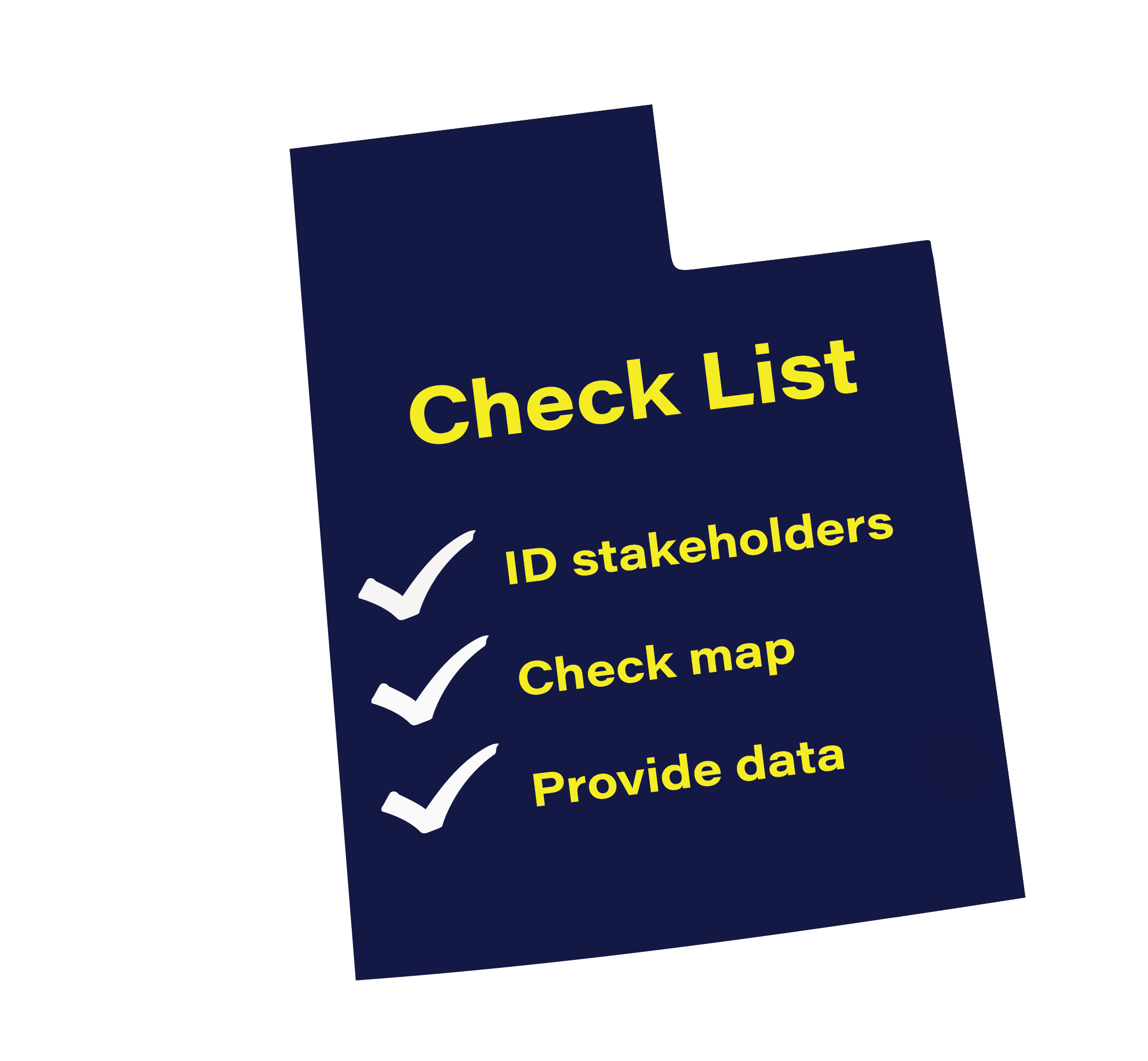
- Base Level Engineering Kickoff
- Discovery
- Phase 2 (Detailed Study) Kickoff
- Hydrology
- Hydraulics
- Flood Risk Review
- Resilience
- Community Coordination and Outreach (CCO) Meeting
Click here for all checklists combined into one file.
Federally recognized Tribal Nations adopt and enforce floodplain management ordinances on lands they manage and/or have land use authority. They can opt to participate in FEMA’s National Flood Insurance Program (NFIP)--which includes Risk MAP--to help them do so.
Note the following about Risk MAP floodplain mapping on tribal lands:
- Tribal organizations can join the NFIP even if no flood hazard map exists for their tribal lands. Conversely, they may request floodplain mapping through Risk MAP without joining the NFIP.
- FEMA mapping data only will only represent floodplains and flood risk. There is no specific identification of buildings or sacred sites, although building and structural outlines may be present on aerial imagery.
- FEMA floodplain mapping projects result in a several flood risk datasets that can be used to protect environmental resources, make land use decisions, and prevent damages to members and tribal assets.
- There is no expectation that the tribe will join the National Flood Insurance Program (NFIP). However, it is important to note that FEMA maps may depict areas where flood insurance is mandated for federally-backed mortgages.
- FEMA mapping data can be used to join the NFIP or be used in local ordinances should there be an interest.
- The data behind FEMA maps can also be used for various grants and project applications with FEMA and other US federal agencies.
- Risk MAP projects are entirely funded by FEMA, there is no cost to the Tribe.
- No floodplain mapping or data collection will ever occur on tribal lands without the expressed interest on the part of the tribe.
Tribal representatives have three options for requesting new or updated floodplain maps:
- They may become engaged in a funded regional project in which Utah Risk MAP is already planning to revise or create new maps. Utah Risk MAP manager Jamie Huff will let tribal representatives know when such a project is starting up.
- They may request help directly through FEMA. Margaret Doherty is the point of contact at FEMA Region 8.
- They may contact the State of Utah directly. The tribal liaison for the Utah Division of Emergency Management (and for Utah Risk MAP) is Anna Boynton.
Tribal Nations can always fund their own floodplain studies. In addition, there are other entities that can perform floodplain mapping, such as the US Army Corps of Engineers. However, if a digital Flood Insurance Rate Map is desired, the results must conform to FEMA standards and be officially approved by FEMA.
If tribes are interested in the non-mapping elements of the National Flood Insurance Program, they may contact Matt Buddie at FEMA’s Region 8 or Tracie Harrison, Utah’s State Floodplain Manager.
How to Use Floodplain Maps
Flood zones can be viewed on the National Flood Hazard Layer.
- Select your area of interest in the map or type in your address of interest in the search bar in the upper left corner.
- Download simplified viewer instructions
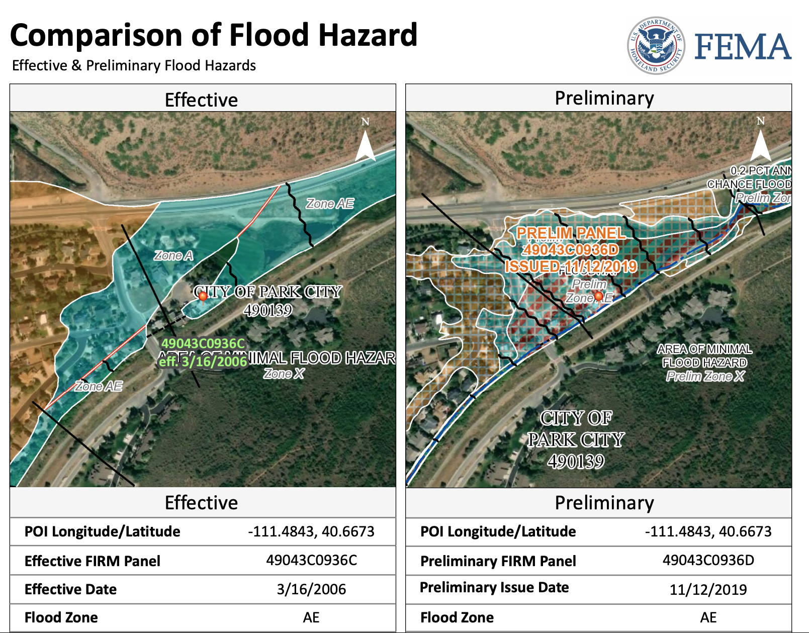
If your area is involved in a Risk MAP project and the preliminary map has been released, you can find that information on the Flood Map Changes Viewer.
Here you can compare the newer preliminary map with the current effective map. You'll see results that look like this:
What is it?
The Base Flood Elevation (BFE) is the elevation of surface water resulting from a flood that has a 1% chance of equaling or exceeding that level in any given year. In other words, the BFE is the expected height of water during a 1%-annual-chance flood event. The BFE is identified in certain Special Flood Hazard Areas (i.e., AE- and VE- zones) on flood maps. Older floodplain maps and maps created using Base Level Engineering may not have BFEs identified.
The BFE is expressed on a flood map as a number of feet. Underneath each A- or V-zone designation the BFE will be marked as “EL #”, where # is a number of feet that varies by location. For example, “EL 3” means the base flood elevation is 3 feet.
What’s it for? The BFE is used by community officials, homeowners, and builders to determine the minimum elevation for structures to be elevated in order to prevent damage during a 1%-annual-chance flood event. The BFE is compared to the elevation of either the lowest adjacent grade and/or the lowest floor of structures. If the structure is below the BFE, particularly if it has a below-grade (below ground) crawl space or basement, the risk of flooding for that structure is high.
How to find the Base Flood Elevation in Zone A
Any new development or substantial improvement within Zone A should have a BFE determined as part of the floodplain permit process. To start, you’re required to look through what already exists. Here are all the possible places you’ll find data that could provide the BFE:
- Check the Flood Insurance Rate Maps (FIRM), Flood Insurance Study (FIS) and municipal records, and check with your community Floodplain Administrator regarding records and studies.
- In addition, check with your community Floodplain Administrator to see if FEMA, US Geological Survey, Army Corps of Engineers, National Resources Conservation Service, or Housing and Urban Development have conducted studies to determine BFE data for the site. The USGS may have also documented high watermarks.
- If a body of water forms a boundary between two communities, the community on the other side may have a detailed study. Such base flood data are valid for both sides of a body of water.
- Existing State studies, including state DOT hydraulics studies for any nearby bridge or major culvert might provide BFE information.
- Hydropower dams likely have a study providing BFEs for their federal license.
You could use data from any of these studies as long as they:
- reasonably reflect flooding conditions expected during the base flood,
- are not known to be technically incorrect, and
- represent the best data available.
If the BFE Doesn’t Already Exist, Hire Someone to Determine It
If the sources above are unable to provide the BFE, the next step is likely to require the property owner or developer to commission a study to determine it. This requires hiring a surveyor or engineer to develop information about the channel including cross-sections, hydrology, and hydraulic modeling. Detailed studies typically use modeling programs such as the US Army Corps of Engineers HEC-RAS software. FEMA’s document on Managing Floodplain Development in Approximate Zone A Areas provides additional information to be reviewed before embarking on the process of BFE determination.
How do I determine the BFE outside the floodplain?
Large new developments may need to know the BFE even if they are outside of the Special Floodplain Hazard Area.
Here is a list of flood zone types along with corresponding descriptions.
Flood Zone Descriptions
What does it mean to be in or outside of a Special Flood Hazard Zone? Here's a slide show to help you understand A and V zones:
Understand the Risk Represented by the Various Flood Zones
The Special Flood Hazard Area (SFHA)* is often called the 100-year floodplain. The latter is a term we at Utah Risk MAP are trying to avoid. It tends to mislead people into thinking that this is an area where flooding will—on average—occur just once in 100 years. A better way to describe a Special Floodplain Hazard Area is to say that there is a 1-percent chance that flood waters will reach or surpass base flood elevation in any given year.
Likewise, the 1-percent annual chance flood is also referred to as the base flood or 100-year flood. It's less confusing to use one of the first two terms.
*The SFHA is where the National Flood Insurance Program's (NFIP's) floodplain management regulations must be enforced and the area where the mandatory purchase of flood insurance applies.
No, they do not. To date, no floodplain products do as they are all based on historical data. However, community officials and planners--floodplain or otherwise--do need to consider the variability and weather extremes that are already in evidence in Utah. Below are a couple of resources for increasing community resilience in the face of climate change:
FEMA Resources for Climate Resilience assists FEMA’s state, local, tribal, and territorial (SLTT) partners in navigating the FEMA resources that are available to support communities in mitigating impacts of climate change.
EPA’s Adaptation Resource Center (ARC-X) is an interactive resource to help local governments effectively deliver services to their communities even as the climate changes. Decision makers can create an integrated package of information tailored specifically to their needs.
Revisions and Appeals
If you believe that the Special Flood Hazard Area (SFHA) was incorrectly mapped, you may submit an application to FEMA for an official revision of the water course and/or elevation relative to the SFHA. This is called a Letter of Map Change (LOMC) request.
FEMA relies on communities to provide notification of changing flood hazard information and to submit the technical support data needed to reflect the updated flood hazards on the flood maps. Although revisions may be requested to change any of the information presented on the NFIP maps, FEMA generally will not revise an effective map unless the changes involve modifications to Special Flood Hazard Areas (one percent annual chance floodplains or flood elevations). Requests for revisions that involve other information (e.g., roads or corporate limits) will typically be filed for future use.
There are two types of revisions.
1. Letter of Map Revision (LOMR)
This is a letter issued to communities by FEMA officially revising a portion of the effective FIRM to show changes to floodplains, regulatory floodways, and/or flood elevations (see 44 CFR Parts 60, 65, and 72). A FIRM panel is not republished.
2. Physical Map Revision (PMR)
A PMR is a republished FIRM panel, with updated FIRM Panel No. and FIRM effective date, incorporating changes to floodplains, regulatory floodways, and/or flood elevations. Because of the increased time and cost involved to change, reprint, and redistribute an NFIP map, compared to a LOMR, a PMR is usually processed when a revision reflects large-scope changes. The republished FIRM will also reflect any effective LOMRs issued within the footprint of the PMR, since the FIRM was last published. In Utah, PMR's are usually accomplished through the Utah Risk MAP but this is not a requirement.
FEMA reviews all requests to revise Flood Insurance Rate Maps (FIRMs) and Flood Insurance Study (FIS) reports. These requests are collectively referred to as MT-2 requests. Follow the link below to see federal guidelines pertaining to MT-2 requests:
Guidance for Flood Risk Analysis and Mapping: Requests and Revisions
An appeal is a formal challenge to proposed BFEs, regulatory floodways, SFHAs, and/or zone designations presented in the preliminary FIS report or on the preliminary FIRM. Appeals are submitted through the community during the 90-day appeal period and must be based on data that shows the proposed information to be scientifically or technically incorrect. Appeals can only be submitted for flood hazard information in the specific areas that are being revised by a Physical Map Revision project.
Letter of Map Revision (LOMR) vs. Appeal: General Information
Guidance for Flood Risk Analysis and Mapping: Requests and Revisions
The appellant bears the cost to appeal. This includes community officials, commercial property owners, and individual property owners affected by the revised flood hazard information either on a preliminary FIRM or in a preliminary FIS report.
Why is the appellant responsible for the appeal data?
The local community is a partner in the development of the preliminary flood risk data. Our results are based on their input and subsequent reviews. That will be important to make sure that maps and products accurately show local flood risk.
Because an appeal must be based on data that shows the new or modified BFEs, base flood depths, floodways, SFHAs, and/or zone designations associated with the preliminary PMR products to be scientifically or technically incorrect.
Through community engagement throughout the project lifecycle, all local available data has been shared and incorporated as appropriate and community concurrence has already occurred at various milestones in the development of the study.
Risk Communications
Flood risk is more common than you think. In fact, flooding is one of the most commonly occurring hazards in Utah. Every community has a flood risk. Some may be higher than others, but no community is immune to flooding. Where it can rain, it can flood.
Routine reminders of flood risks you face in your community can be very effective. Suggestions such as flyers in water bills and in common areas, posts on your website and social media pages and highlights of what your community is doing to mitigate flood risks can increase flood risk awareness in your community. Outreach events can be very effective.
Take advantage of FEMA’s Flood Risk Communication Toolkit. It includes templates and guides for designing a communication plan, effective public meetings, and a social media strategy for addressing flood risk. It is supported by story maps and videos that visually communicate the objectives of updating flood risk data and maps.
FEMA Flood Risk Communication Toolkit for Community Officials
Utah’s State Hazard Mitigation Plan and existing regional plans are great sources of information.
Utah Hazard Mitigation
Floods, What You Should Know When Living in Utah provides helpful facts and tips designed to increase residents' flood awareness and make preparation easy.
Utah Flood Handbook
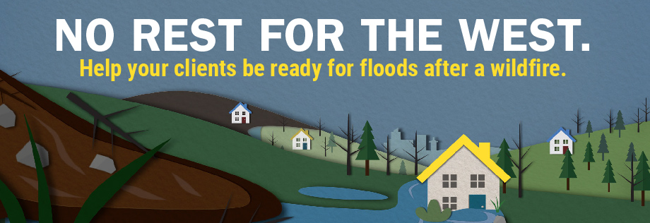
The State Mitigation Team worked with Utah State University Extension to create a flood after fire communications toolkit.
Flood After Fire Tookit
Special Risk Conditions
When a wildfire burns part of a watershed, the resulting burn scar dramatically increases the potential for flooding until vegetation is re-established. This happens because natural, unburned vegetation and soil normally act as a sponge during a rainfall event. However, the heat from a fire can bake the ground, creating a surface that will not absorb water and can increase the speed with which water flows off the slope. When a wildfire compromises or eliminates these normal protective functions, the potential for significant flooding and debris flows increases.
In areas that have been severely burned, post-wildfire risks of floods or debris flows may last for two to five years. After two or three years, the regrowth of vegetation and reduced water repellency of the soil should lower the risk considerably.
The presence of an alluvial fan at the canyon mouth below a fire scar compounds the threat (unabsorbed flow + lots of unchanneled debris). Every year Utahns experience damage and face tremendous costs because of this dangerous combination.
See photos of post-fire alluvial fan debris flows in Utah.
More Resources:
Utah post-wildfire resources put together by Utah State University Extension
and Utah's Post-Fire Mitigation Team: Post-Wildfire Website
US Army Corps of Engineers website on Flooding After Fire
FEMA and the National Flood Insurance Program:
Flood After Fire Campaign (Communications)
FEMA PSA Video: Floods Can Move Mountains: Know Your Risk of Mudflow
An alluvial fan is a fan-shaped area where silt, sand, gravel, boulders, and woody debris are deposited by rivers and streams over a long period of time. Alluvial fans are created as flowing water interacts with mountains, hills, or steep canyon walls. Sediment and debris can be deposited over time by powerful rivers or small creeks. The top, or narrow point, of the alluvial fan is called the “apex,” and the wider portion is called the “apron” or “cone.” Alluvial fans can be small or large, depending on the historical water flows.
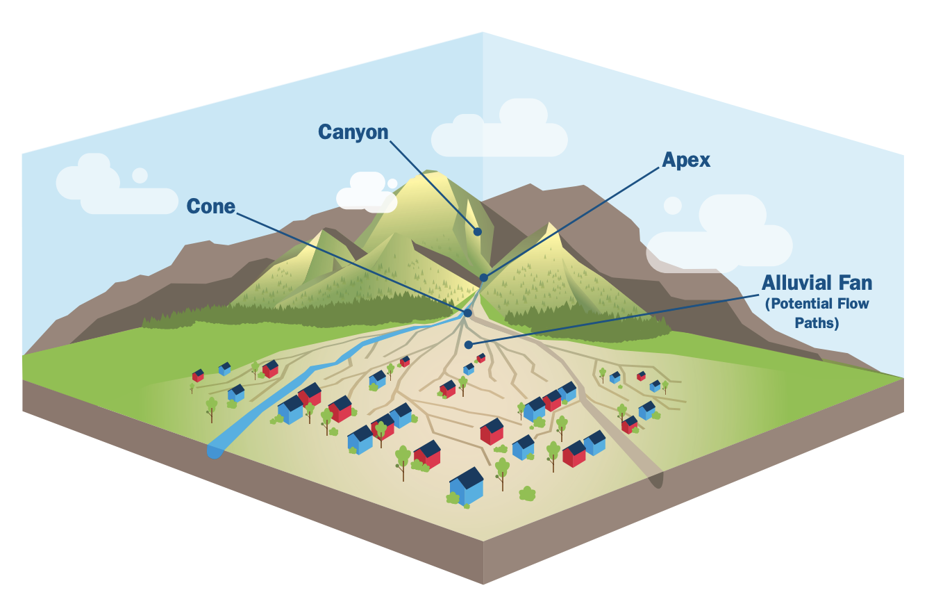
When housing and other developments are built on alluvial fans, they are at high risk from debris flows and related sediment flows. These flows are fast-moving, flow-type landslides composed of a slurry of rock, mud, organic matter, and water that move down drainage-basin channels. When the flow reaches an alluvial fan at a canyon mouth, they no longer are confined by the channel. Instead, they spread laterally--and somewhat unpredictably, depositing their debris on whatever lies in their path.
FEMA fact sheet discussing alluvial fan mapping, zoning, mitigation, building codes and standards, and property protection.
Building and Developing on Alluvial Fans
The Utah Geological Survey has a geological hazards team which produces maps and other information. It provides technical assistance to communities who want to mitigate their alluvial fan risk.
Debris Flows and Alluvial Fans
How do geologists evaluate debris-flow hazards on alluvial fans to ensure safe development? This 2005 publication by Richard Giraud at the Utah Geological Survey will tell you how:
Guidelines for the Geologic Evaluations of Debris-Flow Hazards on Alluvial Fans in Utah
Utah Silver Jackets Team and the U.S. Army Corps of Engineers have produced the following informational products for those with little knowledge of alluvial fans and associated risk:
While levees can help reduce the risk of flooding, it is important to remember that they do not eliminate the risk. Levees can and do deteriorate over time and must be maintained to retain their effectiveness. When levees fail, or are overtopped, the results can be catastrophic. In fact, the flood damage can be greater than if the levee had not been built.
FEMA's Living with Levees site has information about risk, guidance and standards, and communications for different types of audiences,
So You Live Behind a Levee is a booklet about levees by the American Society of Civil Engineers
Utah Risk MAP does not map flash flood probability in remote, non-populated areas. Nevertheless, flash floods are a serious risk to visitors to southern Utah’s desert lands—both inside and outside national and state parks. The U.S. Army Corps of Engineers Silver Jackets Program has put together some information on slot canyon flooding.
Click here to go to their web page.
Click here for a video on flash floods in slot canyons.
be in the know
Latest Flood and Floodplain News
High and Dry Newsletter
Utah Floodplain Program and Utah Floodplain and Stormwater Management Association (UFSMA)
Risk MAP Blog
Utah Division of Emergency Management RISK MAP Progam